
Dedicated to Port Lavaca, Texas - Then and Now...
Kayak Destinations in Upper Lavaca Bay
Hot spots within two miles of the Six Mile Park & Boat Ramp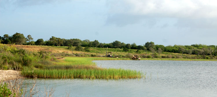
Ready to make a fishing trip to Port Lavaca, but don't know where to fish? Just follow the numbers... - 1. Six Mile Park and Boat Ramp
- 2. Placedo Cove
- 3. Placedo Creek
- 4. Keeran's Point and Flats
- 5. East Shoreline of Keeran's
- 6. Garcitas Creek
- 7. Oyster Lake
- 2. Placedo Cove
- 8. Lake
- 9. Cut Thru Marsh
- 10. Deep Slough
- 11. Mud Lake
- 12. East Shoreline Garcitas Cove
- 13. Garcita Cove
- 14. Bennett's Point
- 9. Cut Thru Marsh
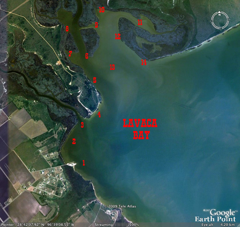
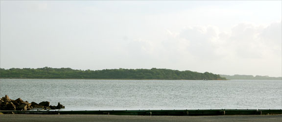
Part I There are numerous locations in upper Lavaca Bay that are great fishing destinations for kayakers - all located within a couple of miles of the Six Mile Park in Calhoun County, Texas. There are two ramps located at the Park, found at the end of Park Road. Park Road is accessed from FM 1090 and about six miles from Hwy 35 and the FM1090 intersection in Port Lavaca. If coming from Victoria, take a left onto FM 1090 about 2 miles past the town of Placedo. Just follow the road until you come to Park Road - right before the Six Mile Assembly of God Church. Here's a little orientation to get things started quickly when you first
drive up to the 6 Mile Park. Looking 1. Six Mile Park & Boat Ramp - Here you'll find a pier, play ground, picnic tables and two boat ramps. Kayaks are often launched to the left just as you drive over the small creek at the entrance to the Park. The creek is often a good spot to drop a castnet if you want bait. 2. Placedo Cove - Between the boat ramp and Placedo Creek, lies a small marsh-lined half moon shaped cove. The bottom is hard in most places and as a result, when the water is clear it's a great spot for a quick nighttime flounder gigging trip - no boat required. The marsh grass along the cove holds shrimp, holds baitfish and both reds and flounder can often be found feeding along the grassy front or back in the grass. Fish can be found from the very small sandy area to the left as you drive in to the park, all the way to Placedo Creek. This is also a good trip for anyone that wants to leave the boat at home and just cast the flats. 3. Placedo Creek - Following the shoreline of the cove, one will come to Placedo Creek, about 500 yards in a straight line from the ramp, but a little further by way of the shoreline. The mouth of Placedo Creek is deep so be careful if you approach it on foot. Either side of the creek is a good place to park and cast into the deeper water's of the creek or toward the shallows of the cove or the flats toward the bay on the east side of the creek. Trout will be most frequently caught here.
4. Keeran Point and Flats - To the east of Placedo Creek is a bluff that represents the end of high ground that forms the western edge of Garcitas Creek (and beyond). There is a very large flat that extends from the bluff well out into the bay. Schools of reds are often encountered on the flat and they can be spotted tailing or busting the water chasing bait. Birds will also follow reds as they feed and they can be spotted hovering and diving low over the water. Don't be surprised to see small numbers of birds following big schools of reds. Trout will usually be found in deeper water and flounder in shallower. Great place to have a gig and light after dark, especially in the spring. (Texas waters will be closed to gigging in October and November beginning in 2009. ) 5. Keeran Point - West Shoreline - Rounding the bluff at Keeran's, a grassy shoreline extends toward the north that will eventually lead to Garcitas Creek. Reds and flounder are often caught along this shoreline. Just a little to the east of this shoreline is the old Garcitas Creek channel. This shoreline is a great spot to locate reds or trout that are moving between the bay and deeper water's of the creek or just following bait around the flats. The channel is today very shallow compared to the old, that is until you get near to where the creek starts to enter the cove. Shallow running flats boats usually enter Garcitas Creek following this channel. Water depth is never a problem for kayakers to maneuver this shoreline. 6. Garcitas Creek Mouth - Boats often anchor at the point on the right entering Garcitas Creek. Anglers can can cast into the deep creek for trout or throw toward the flats for reds. The shoreline that extends to the right of the mouth is grassy and reds are often found schooling along the shoreline. This shoreline extends to a cut that connect the back area of the cove to Garcitas Creek. More on this later. 7. Oyster Lake(s) After reaching the mouth of Garcitas Creek, there will be two lakes (separated by about 300 hundreds yards of marsh that are located on the west side of the creek. Both are connected by a narrow slough in the back of the marsh near the high ground. Reds can often be found in either lake along with trout and flounder. When tidal currents are flowing, bait will be moved through this "back door" between the little lakes. Fish will often be found positioned to take advantage of the smorgasbord being pushed along by the current. The sides of Garcitas Creek drop off quickly and along the edge of the flats and the creek create a transition zone for fish moving off the flats to the cooler deeper channel in the warm months or coming out of the channel to enter the flats for a little sun in winter.
|
 to the left as
you drive in you'll notice the marsh to the left in the top picture. It
bends to form a cove that includes the place where Placedo Creek meets Lavaca
Bay. This is Placedo Cove and following it will bring your eyes to a large
bluff on the bay. - Keeran Point... Looking toward the Point the area to
the right and beyond is Garcitas Cove.
to the left as
you drive in you'll notice the marsh to the left in the top picture. It
bends to form a cove that includes the place where Placedo Creek meets Lavaca
Bay. This is Placedo Cove and following it will bring your eyes to a large
bluff on the bay. - Keeran Point... Looking toward the Point the area to
the right and beyond is Garcitas Cove.
Copyright 2006-10 - portlavacamainstreet.com - All rights
reserved.