
Dedicated to Port Lavaca, Texas - Then and Now...
Kayak Destinations in Upper Lavaca Bay
Hot spots within two miles of the Six Mile Park & Boat Ramp
Part II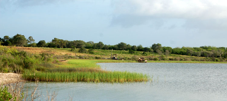
Ready to make a fishing trip to Port Lavaca, but don't know where to fish? Just follow the numbers... - 1. Six Mile Park and Boat Ramp
- 2. Placedo Cove
- 3. Placedo Creek
- 4. Keeran's Point and Flats
- 5. East Shoreline of Keeran's
- 6. Garcitas Creek
- 7. Oyster Lake
- 2. Placedo Cove
- 8. Lake
- 9. Cut Thru Marsh
- 10. Deep Slough
- 11. Mud Lake
- 12. East Shoreline Garcitas Cove
- 13. Garcita Cove
- 14. Bennett's Point
- 9. Cut Thru Marsh
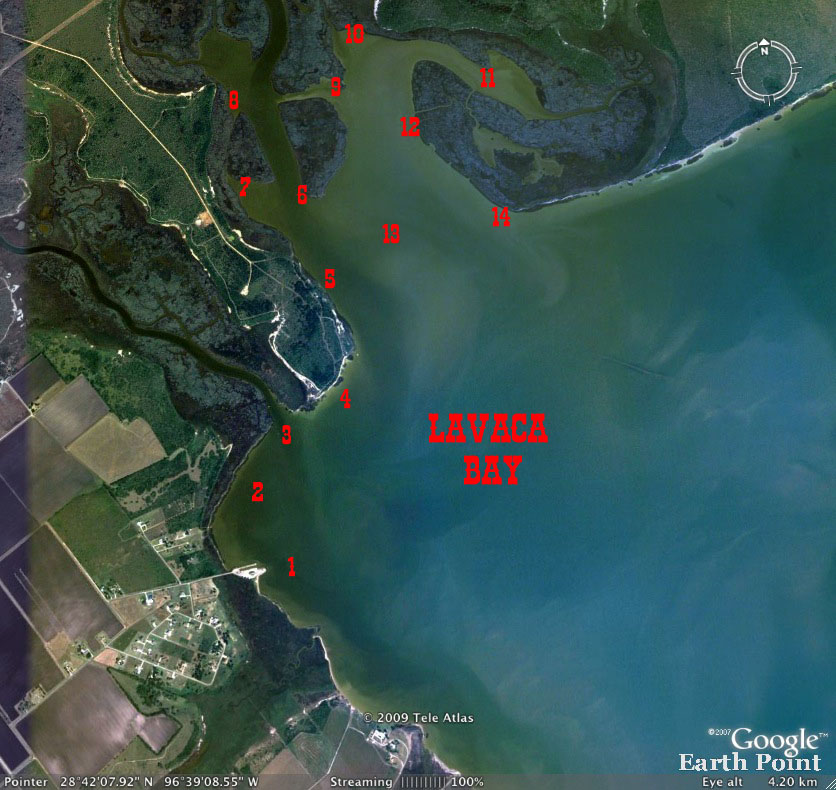
Part II There are numerous locations in upper Lavaca Bay that are great fishing destinations for kayakers - all located within a couple of miles of the Six Mile Park in Calhoun County, Texas. There are two ramps located at the Park, found at the end of Park Road. Park Road is accessed from FM 1090 and about six miles from Hwy 35 and the FM 1090 intersection in Port Lavaca. If coming from Victoria, take a left onto FM 1090 - about 2 miles past the town of Placedo. Just follow the road until you come to Park Road - right before the Six Mile Assembly of God Church. Here's a little orientation to get things started quickly when you first
drive up to the 6 Mile Park. Looking 9. Cut From Garcitas to the Cove - Across the creek to the east from the second lake, a small cut can be seen extending to the east. Fish often move through the cut and will enter the upper part of Garcitas Cove upon their exit of the cut. The cut is fairly narrow and shallow. At times during the winter it's not navigable at all. When bay levels are normal, boats often run through the cut and may not be able to slow down without running aground. Reds are frequently spotted in the cut heading into or out of the cove. 10. Slough in Upper Cove - Upon exiting the eastern end of the cut, several fishing options are available. To the left, after exiting the cut, is a shoreline with scattered shell that extends to a fairly deep slough at the upper end of the cove that winds around in the marsh. (That's just what slough's do, you know.) The slough will be loaded with bait at times on an incoming current. Reds move in and out following bait moved by the currents and they can be found feeding on bait near the mouth or further inside. 11. Mud Lake - Crossing the slough and following the marsh shoreline brings you to Mud Lake. This is a fairly large lake with grassy shorelines and, you guessed it, - a mud bottom. Very soft mud, by the way. It is often full of mullet and reds. At the very back of the lake is a deep slough that winds deep into the marsh. This slough is similar in depth to the one in the upper cove. It's best fished on an outgoing current that will empty bait into Mud Lake. 12. Eastern Shoreline of Garcitas Cove - The shoreline on the outside of Mud Lake extends toward Lavaca Bay and Bennett's Point at the bay front. Along the marsh there are two sloughs that extend from the cove through the marsh and into Mud Lake. Shrimp and other baitfish move back and forth through the sloughs and as you can imagine, mostly reds - but a few flounder, too, will line up waiting for tasty morsels to be swept to them by the current. One frustrating experience you will have at times along this shoreline (or others with an extensive growth of grass), is an encounter with reds feeding in the grass. Why it's frustrating is that you will not, without a great deal of luck, be able to catch one. It's not because of a shortage of reds; at times it may even sound like a basketball team you can not see running to and fro. Baits cast into the grass hang up on the grass - yanking on the lure spooks the reds. Attempts to get in closer, spooks the reds. Spook one red and you've spooked them all! If one does hit your offering, chances are you'll never get him out of the grass. The hook is going to pull or the line is going to break. You will hear them popping, popping and more popping and see the grass bend as they move along. It's fun to watch, but it's better to look for a red or two that might be following the school, just along the edge of the grass. There is one solution to this dilemma, however, that works. I call it heading them off at the pass... When reds are feeding on shrimp in the grass they are typically moving in one direction and they will continue in that direction for quite some time - unless spooked! Once you determine which direction they are headed, and are familiar with the coastline, you can paddle ahead of them to where you know there is an opening in the grass - and wait. It's quite a thrill to be sitting near a bare spot in the grass, knowing the reds will soon be exposed while they cross the open water. (A bare spot in the grass will only have to be a few feet wide. Along this shoreline there are two nice ambush points, one is wide and the other narrow and theese Before they get there, if you don't want to take a chance with your casting skills at a critical moment, you can cast into the opening several times, if necessary, to get it in the right position before they arrive. Then, you just let the bait lie in wait. When they arrive, just give it a little twitch and usually there's an immediate hit. This option takes away the issue of making a bad cast at the right time. You'll often only get one chance when the reds enter the opening - so it has to be right. I've had this tactic work like a charm many times, but occasionally it spooks a fish and they all run. Just dropping a cast into the red bunch often gets a quick hook up. 13. Garcitas Cove - The cove is wide and the bottom ranges from hard sand to soft mud - small amounts of scattered shell can be found in many areas. The deeper water with shell can be found near the telephone sized pole sitting about three feet above the water about on the line from Bennett's to Keeran's near the east bank. Shell is scattered around The cove is great to drift from any angle. Watch for gulls low on the water anywhere in the cove. If you see a large number sitting on the water or hovering - they will very likely be on reds. 14. Bennett Point - It's kind of hard to describe when you are at Bennett's Point but you will know it when you are. The shoreline back to Mud Lake will be visible to your left - and, it is here, you can also see the north shoreline of Lavaca Bay that extends to the right all the way to the west shore line of the Lavaca River (about 3 miles). The exact location is really not important. It's 1.6 miles from the ramp (in a straight line) to Bennett's Point.
|
 to the left as
you drive in you'll notice the marsh to the left in the top picture. It
bends to form a cove that includes the place where Placedo Creek meets Lavaca
Bay. This is Placedo Cove and following it will bring your eyes to a large
bluff on the bay. - Keeran Point... Looking toward the Point the area to
the right and beyond is Garcitas Cove.
to the left as
you drive in you'll notice the marsh to the left in the top picture. It
bends to form a cove that includes the place where Placedo Creek meets Lavaca
Bay. This is Placedo Cove and following it will bring your eyes to a large
bluff on the bay. - Keeran Point... Looking toward the Point the area to
the right and beyond is Garcitas Cove.
Copyright 2006-10 - portlavacamainstreet.com - All rights
reserved.